This study focuses on investigating the use of artificial intelligence (AI) techniques and technologies in a smartphone experience to assist journey planning in tourism. More specifically, it set out to develop 3 major features, namely: a path-finding system (which does not necessarily follow the shortest path); a recommender system; and augmented reality (AR) tools for navigation assistance. The AI was implemented by using an adaptable search space reflecting the content of a map that would be capable of learning through past user experiences, and to change results dynamically.
In the developed application, the intelligent search space uses point values placed in junctions of a map, each signifying a choice in travelling direction. These points contain simulated values to signify preference variance, such as the popularity of that point or its relevance to various historical periods. Information may be changed to test varying trends, to reflect real-life patterns. In doing so, the results presented in the features outlined below could be altered.
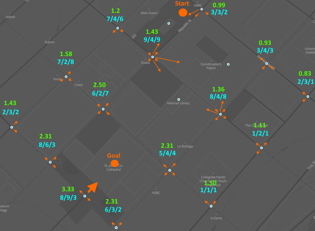
The path-finding system used the A* search algorithm [1], which connects vertices in a graph from a start point to a goal point in the most inexpensive way possible. This is an extension of the Dijkstra algorithm [2], in that it includes an intelligent heuristic. User preferences in this system were the main driving element in building an optimal path to the destination that would best match the user’s choice of heritage sites. Once created, this was then given to the user through a map with the generated trail.
The recommender system retrieved information from the user-assigned preferences to create a score for each destination of interest. These destinations would be ranked and sorted before being displayed in a list, with the highest scores appearing at the top. These suggestions were then used to direct the user through the path-finding system to the chosen destinations.
The AR features include destination markers, as well as a direction pointer that rotated according to the next location to be followed. The AR markers are 3D models categorised according to the historical period of the locations they identify, were designed to hover over the real-world location of the respective sites. An AR arrow would appear on the application screen when a path is generated, and rotates toward the next geographic position of the closest node to travel to.
The developed application appeared to have achieved each of these features to successfully make use of the search space information to draw their conclusions. Several example paths from the path-finding system were duly tested and evaluated by a professional tour guide, who confirmed that the suggested paths were indeed appropriate in reflecting user preferences, yet were not necessarily the optimal paths in practice.
The recommender system was tested with a large combination of user preferences and destinations of different qualities, all of which have proved loyal to user preferences. The AR features all behaved in accordance to their navigation intention. Nevertheless, they displayed a degree of inaccuracy that could prove confusing during the navigation process.
References/Bibliography
[1] Peter E Hart, Nils J Nilsson, and Bertram Raphael. A formal basis for the heuristic determination of minimum cost paths. IEEE transactions on Systems Science and Cybernetics, 4(2):100–107, 1968.
[2] Edsger W Dijkstra et al., A note on two problems in connexion with graphs. Numerische mathematik, 1(1):269–271, 1959.
Course: B.Sc. IT (Hons.) Artificial Intelligence
Supervisor: Dr Vanessa Camilleri