The progressive ageing of the population has transformed mild cognitive impairment (MCI) into a prevalent condition among the elderly. Outdoor spatial disorientation is the most critical symptom, increasing the rate of mazeophobia (fear of being lost) or wandering into dangerous situations. This suggests an increasing demand for socio-healthcare services to preserve the quality of life of older adults. However, MCI could be delayed or prevented with the help of physical exercise and social interaction [1]. Tests carried out to this effect have suggested that 47% of the participants with MCI remained unaltered, whereas 31% returned to normal over an average of 4.7 years of follow-up [2].
The focus of this study was to explore available technologies in this context and to develop an effective location-aware application aimed at supporting persons with MCI, and assisting them when finding themselves in ‘wandering situations’. The underlying principle of this study is to shed light on the construction of location-based mobile applications as an alternative to factors that tend to undermine the autonomy of persons with MCI, such as medication, institutionalisation, and mobility restrictions. Moreover, such technology-based solutions would alleviate the carer’s burden and possibly make their involvement more effective.
Interviews with geriatricians were conducted in order to gain a deeper understanding of MCI and obtain insight into the problem domain. Among other findings, there was a general consensus that prevention would be better than remedial action. This preliminary survey not only assisted in the prototype design stage, but also provided indications for functionalities of the proposed application.
The main objective of the application was to facilitate the setting up of a geofence that would trigger an alert to the patient when their device would enter or exit a predefined boundary around their home. Additional assistance, real-time monitoring and reminders could also be implemented in cases where the user should want to go outdoors intentionally. This application (named TrackPal) integrates modern technologies such as: location-based services (LBS), Geographical Positioning System (GPS), online services that include real-time maps, and routing data such as Google Maps, mobile internet data services, notification services, and speech-driven technologies, which would act as safeguards against spatial disorientation. Combining these technologies with modern smartphones would serve as a substitute for dedicated assistive devices, thus eliminating the burden of carrying a separate device and the stigma of visible assistive devices [3].
Background geolocation data, including geofence alerts and real-time co-ordinates, would be transmitted from the application running on the user’s mobile device to the backend system. The system developed was tested for accuracy, reliability, and user-friendliness. The main errors could be attributed to slight co-ordinate inaccuracies relative to GPS when the user entered an indoor location, resulting in repetitive geofence alerts.
This study seeks to increase the awareness of individuals and public or private entities working in this field, with regard to the daily challenges experienced by persons with MCI. The ultimate intention is to contribute towards improving the well-being, peace of mind and independence of elderly persons.
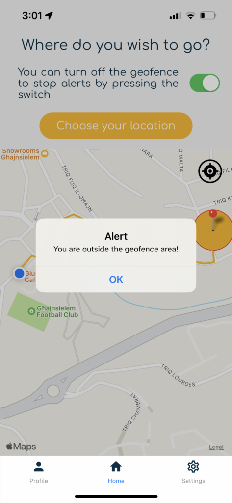
Figure 1. Home screen of the TrackPal app issuing an alert when the user exits the predefined geofence area around their home (directions back to their home are also visible)
Student: Mariah Balzan
Supervisor: Dr Michel Camilleri